
Contents
- I. Introduction
- II. Role of Drones in Conservation
- III. Satellite Imaging and Conservation
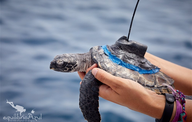
- IV. Tracking and Monitoring Wildlife with GPS Technology
- V. Artificial Intelligence (AI) in Conservation
- VI. Internet of Things (IoT) and Conservation
- VII. Blockchain Technology for Wildlife Conservation
- VIII. Best Wildlife Conservation Apps
I. Introduction

Technology has revolutionized various industries, and conservation efforts are no exception. With the advancement of technology, conservationists now have powerful tools at their disposal to protect and preserve our natural environment. From satellite imaging to artificial intelligence, these technological innovations have greatly enhanced our ability to understand, monitor, and address environmental challenges.
In this article, we will explore how technology is advancing conservation efforts and the positive impact it is having on our planet. We will delve into the various ways in which technology is being utilized, such as remote sensing, data analysis, and wildlife tracking. By harnessing the power of technology, conservationists are able to gather valuable information, make informed decisions, and implement effective strategies to safeguard our ecosystems.
Moreover, we will discuss the role of citizen science and how technology has made it easier for individuals to contribute to conservation efforts. Through smartphone apps and online platforms, people from all walks of life can actively participate in data collection, species identification, and environmental monitoring. This democratization of conservation allows for greater public engagement and empowers individuals to make a tangible difference in protecting our natural world.
Lastly, we will explore the challenges and potential risks associated with the use of technology in conservation. While technology offers immense benefits, it is important to address issues such as data privacy, ethical considerations, and the digital divide. By acknowledging these challenges, we can work towards developing responsible and inclusive technological solutions that prioritize both environmental preservation and societal well-being.
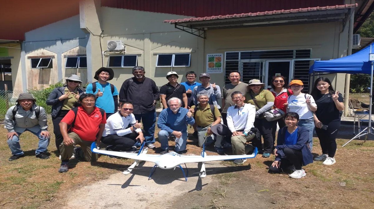
II. Role of Drones in Conservation
A. Benefits of using drones in conservation efforts
Drones have revolutionized the field of conservation by providing researchers and conservationists with a powerful tool to monitor and protect the environment. These unmanned aerial vehicles offer numerous benefits that contribute to the advancement of conservation efforts.
Firstly, drones enable researchers to collect data more efficiently and accurately. Equipped with high-resolution cameras and sensors, drones can capture detailed images and videos of remote and inaccessible areas. This allows scientists to study wildlife populations, monitor habitat changes, and detect illegal activities such as poaching and deforestation.
Moreover, drones provide a cost-effective solution for conservation projects. Traditional methods of data collection often involve expensive equipment, extensive manpower, and time-consuming fieldwork. With drones, researchers can cover large areas in a shorter period of time, reducing costs and increasing efficiency.
Another significant advantage of using drones is their ability to minimize human disturbance. In the past, researchers had to physically enter sensitive ecosystems, which could disrupt wildlife behavior and cause stress to the animals. Drones, on the other hand, can observe and monitor from a distance, minimizing the impact on the environment and ensuring the accuracy of the collected data.
Furthermore, drones have proven to be invaluable in disaster response and recovery efforts. After natural disasters such as hurricanes, earthquakes, or wildfires, drones can be deployed to assess damage, locate survivors, and identify areas in need of immediate attention. This real-time information helps authorities and relief organizations make informed decisions and allocate resources effectively.
B. Case studies of successful drone applications in conservation
Several case studies demonstrate the effectiveness of drones in conservation efforts. One notable example is the use of drones to combat wildlife poaching in Africa. In countries like Kenya and South Africa, drones equipped with thermal imaging cameras have been deployed to track and monitor poachers, leading to increased arrests and reduced poaching activities.
In the field of marine conservation, drones have played a crucial role in monitoring and protecting marine ecosystems. In Australia’s Great Barrier Reef, drones equipped with hyperspectral cameras have been used to detect coral bleaching and assess the health of the reef. This data helps scientists understand the impacts of climate change and implement targeted conservation measures.
Additionally, drones have been instrumental in studying and conserving endangered species. In the Galapagos Islands, drones have been used to monitor the population of giant tortoises, allowing researchers to track their movements, study their behavior, and implement conservation strategies to protect their habitats.
C. Limitations and challenges of using drones in conservation
While drones offer immense potential in conservation efforts, there are also limitations and challenges that need to be addressed.
One major limitation is the limited flight time and range of drones. Most consumer-grade drones have a flight time of around 20-30 minutes and a range of a few kilometers. This restricts their ability to cover large areas or conduct long-term monitoring without frequent battery changes or recharging.
Another challenge is the need for skilled operators and data analysts. Operating a drone requires technical expertise and knowledge of aviation regulations. Additionally, analyzing the vast amount of data collected by drones can be time-consuming and requires specialized skills in data processing and interpretation.
Furthermore, weather conditions can significantly affect drone operations. Strong winds, rain, or extreme temperatures can pose risks to the drone’s stability and performance. This limits their usability in adverse weather conditions and remote locations with challenging terrain.
Lastly, privacy concerns and ethical considerations must be taken into account when using drones for conservation purposes. Drones equipped with cameras can inadvertently capture images of individuals or private property, raising concerns about privacy infringement. Clear guidelines and regulations need to be established to address these issues and ensure responsible drone use.
III. Satellite Imaging and Conservation
Satellite imaging has revolutionized the field of conservation by providing valuable insights and data that were previously unattainable. This technology has enabled scientists and researchers to monitor and protect wildlife populations, detect deforestation, and identify illegal activities. In this section, we will explore how satellite imaging aids in conservation, provide examples of its application in monitoring wildlife populations, and discuss its potential in detecting deforestation and illegal activities.
A. How satellite imaging aids in conservation
Satellite imaging plays a crucial role in conservation efforts by providing a comprehensive view of the Earth’s surface. It allows scientists to monitor large areas of land and water, providing valuable information about the distribution and abundance of wildlife, as well as the health of ecosystems. By analyzing satellite images, researchers can identify habitat loss, track migration patterns, and assess the impact of human activities on the environment.
One of the key advantages of satellite imaging is its ability to capture data over time. By comparing images taken at different intervals, scientists can track changes in land use, vegetation cover, and water bodies. This information is essential for understanding the long-term effects of climate change, deforestation, and other environmental factors on biodiversity.
Furthermore, satellite imaging allows for the monitoring of remote and inaccessible areas. In regions where on-the-ground surveys are challenging or dangerous, satellite images provide a safe and cost-effective alternative. This technology has been particularly valuable in monitoring endangered species, such as tigers and elephants, in remote forests and protected areas.
B. Examples of satellite imaging in monitoring wildlife populations
Satellite imaging has been instrumental in monitoring wildlife populations across the globe. One notable example is the use of satellite imagery to track the movements of marine animals, such as whales and sea turtles. By analyzing satellite data, scientists can identify feeding grounds, migration routes, and breeding areas, allowing for targeted conservation efforts.
In addition, satellite imaging has been used to monitor the populations of endangered species in remote and inaccessible regions. For instance, in the Arctic, satellite images have helped researchers track the movements of polar bears and assess the impact of melting sea ice on their habitat. Similarly, in the Amazon rainforest, satellite data has been used to estimate the population size of elusive species like jaguars and tapirs.
Moreover, satellite imaging has proven effective in monitoring the illegal wildlife trade. By analyzing satellite images, researchers can detect and track illegal activities, such as poaching and the smuggling of wildlife products. This information is crucial for law enforcement agencies and conservation organizations in their efforts to combat wildlife crime.
C. Potential for satellite imaging in detecting deforestation and illegal activities
Satellite imaging holds immense potential in detecting deforestation and illegal activities, which pose significant threats to biodiversity and ecosystems. By analyzing satellite images, scientists can identify areas of deforestation, track the expansion of agricultural land, and assess the impact of logging activities.
Furthermore, satellite imaging can be used to detect and monitor illegal mining operations, which often result in habitat destruction and pollution. By analyzing changes in land cover and vegetation, researchers can identify areas where illegal mining activities are taking place and provide evidence for law enforcement agencies.
In addition, satellite images can help identify and monitor illegal fishing activities. By analyzing changes in sea surface temperature and ocean color, scientists can detect the presence of illegal fishing vessels and track their movements. This information is vital for enforcing fishing regulations and protecting marine ecosystems.
IV. Tracking and Monitoring Wildlife with GPS Technology
Tracking and monitoring wildlife is crucial for conservation efforts, as it provides valuable insights into animal behavior, migration patterns, and habitat usage. In recent years, GPS technology has revolutionized the way researchers track and monitor wildlife, offering a more accurate and efficient method compared to traditional tracking techniques. In this section, we will explore the overview of GPS technology in wildlife tracking, examine case studies of GPS tracking in conservation research, and discuss the challenges and limitations associated with GPS tracking in wildlife monitoring.
A. Overview of GPS technology in wildlife tracking
GPS, or Global Positioning System, is a satellite-based navigation system that allows precise location tracking anywhere on Earth. In wildlife tracking, GPS technology is used to attach small, lightweight devices, such as collars or tags, to animals. These devices are equipped with GPS receivers that receive signals from multiple satellites, enabling them to determine the animal’s exact location.
The use of GPS technology in wildlife tracking offers several advantages. Firstly, it provides researchers with accurate and real-time data on animal movements, allowing them to understand the spatial ecology of different species. This information is crucial for identifying key habitats, migration routes, and potential threats to wildlife populations.
Additionally, GPS tracking allows researchers to collect data on animal behavior, such as foraging patterns, territoriality, and social interactions. By analyzing these behavioral patterns, scientists can gain insights into the ecological dynamics of wildlife populations and make informed conservation decisions.
Furthermore, GPS technology enables researchers to track animals over long distances and in remote or inaccessible areas. This capability is particularly valuable for studying migratory species or animals that inhabit challenging environments, such as marine mammals or birds.
B. Case studies of GPS tracking in conservation research
There have been numerous successful case studies showcasing the effectiveness of GPS tracking in conservation research. One notable example is the study of sea turtle migration. By attaching GPS devices to sea turtles, researchers have been able to track their movements across vast oceanic regions. This data has revealed important migratory corridors, feeding grounds, and nesting sites, helping conservationists develop targeted conservation strategies to protect these endangered species.
Another case study involves the tracking of large terrestrial mammals, such as elephants and tigers. GPS collars fitted on these animals have provided valuable insights into their ranging behavior, habitat preferences, and interactions with human settlements. This information has been instrumental in designing wildlife corridors, mitigating human-wildlife conflicts, and implementing effective conservation measures.
Furthermore, GPS tracking has been instrumental in studying bird migration patterns. By attaching GPS tags to migratory birds, researchers have unraveled the mysteries of their long-distance journeys, identifying critical stopover sites and understanding the factors influencing their migration routes. This knowledge is crucial for the conservation of migratory bird species, as it helps protect their habitats and ensure their safe passage during migration.
C. Challenges and limitations of GPS tracking in wildlife monitoring
While GPS technology has revolutionized wildlife tracking, it is not without its challenges and limitations. One major limitation is the battery life of GPS devices. Depending on the tracking interval and the power requirements of the device, batteries may need to be replaced or recharged frequently. This can be logistically challenging, especially for animals in remote or inaccessible areas.
Another challenge is the accuracy of GPS data. While GPS technology provides precise location information, certain factors such as dense vegetation, rugged terrain, or urban environments can interfere with signal reception and reduce accuracy. Researchers must consider these limitations when interpreting GPS data and ensure they account for potential errors in their analyses.
Furthermore, the cost of GPS devices and associated data analysis can be prohibitive for some research projects. The initial investment in purchasing GPS equipment and the ongoing expenses of data management and analysis may limit the scalability of GPS tracking in certain contexts.
Lastly, ethical considerations must be taken into account when using GPS tracking in wildlife monitoring. Researchers must ensure that the devices used do not cause harm or discomfort to the animals and that the data collected is used responsibly and in compliance with animal welfare guidelines.
V. Artificial Intelligence (AI) in Conservation

In recent years, the field of conservation has witnessed a remarkable advancement in technology, with Artificial Intelligence (AI) playing a crucial role. AI has revolutionized the way large datasets are analyzed for conservation research, enabling scientists to gain valuable insights and make informed decisions. Additionally, AI applications have been instrumental in species identification and monitoring, providing conservationists with efficient tools to protect and preserve biodiversity. However, the integration of AI in conservation also raises ethical considerations and concerns that need to be addressed.
A. Role of AI in analyzing large datasets for conservation research
Conservation research often involves analyzing vast amounts of data collected from various sources, such as satellite imagery, camera traps, and acoustic recordings. Traditionally, this process has been time-consuming and labor-intensive, requiring experts to manually analyze the data. However, AI algorithms have the ability to process and analyze large datasets at an unprecedented speed, significantly reducing the time and effort required.
AI algorithms can be trained to recognize patterns, detect anomalies, and extract valuable information from complex datasets. For example, AI can be used to analyze satellite imagery and identify changes in land cover, helping researchers monitor deforestation rates and habitat loss. Similarly, AI can analyze acoustic recordings to identify species-specific vocalizations, aiding in the study of animal behavior and population dynamics.
By automating data analysis, AI enables conservationists to gain insights and identify trends that would otherwise be challenging to detect. This, in turn, facilitates evidence-based decision-making and the development of effective conservation strategies.
B. AI applications in species identification and monitoring
One of the most significant contributions of AI to conservation is its applications in species identification and monitoring. Traditional methods of species identification often rely on manual observation and expert knowledge, which can be time-consuming and prone to errors. However, AI algorithms can be trained to recognize and classify species based on various characteristics, such as color patterns, morphological features, and vocalizations.
AI-powered species identification tools, such as computer vision and machine learning algorithms, have been developed to assist in the identification of plants, animals, and insects. These tools can analyze images or recordings and provide accurate species identification within seconds. This not only saves valuable time but also allows non-experts to contribute to species monitoring efforts.
Furthermore, AI can be used to monitor species populations and track their movements. For instance, camera traps equipped with AI algorithms can automatically detect and count individual animals, providing valuable data on population size and distribution. This information is crucial for assessing the effectiveness of conservation interventions and identifying areas that require immediate attention.
C. Ethical considerations and concerns regarding AI in conservation
While AI offers numerous benefits to conservation efforts, it also raises ethical considerations and concerns that need to be carefully addressed. One of the primary concerns is the potential bias in AI algorithms. AI algorithms are trained on existing datasets, which may contain inherent biases and inaccuracies. If these biases are not identified and addressed, AI algorithms can perpetuate and amplify existing inequalities and biases in conservation decision-making.
Another ethical concern is the potential displacement of human expertise. As AI becomes more advanced, there is a risk of relying too heavily on automated systems and neglecting the valuable insights and knowledge that human experts bring to conservation. It is important to strike a balance between the use of AI and human expertise, ensuring that AI tools complement and enhance human decision-making rather than replace it.
Additionally, there are concerns regarding data privacy and security. AI algorithms require access to large amounts of data to learn and make accurate predictions. However, the collection and storage of sensitive ecological data raise concerns about privacy and the potential misuse of data. Conservation organizations must establish robust data governance policies and ensure that data collection and storage comply with ethical and legal standards.
VI. Internet of Things (IoT) and Conservation
The Internet of Things (IoT) has revolutionized various industries, and conservation efforts are no exception. IoT devices have become valuable tools in monitoring and protecting habitats, as well as combating poaching. In this section, we will explore how IoT devices contribute to conservation efforts, provide examples of IoT applications in habitat monitoring and anti-poaching efforts, and discuss potential challenges and risks associated with IoT in conservation.
A. How IoT devices contribute to conservation efforts
IoT devices play a crucial role in conservation efforts by collecting and analyzing real-time data, enabling researchers and conservationists to make informed decisions. These devices are equipped with sensors that can monitor various environmental parameters such as temperature, humidity, air quality, and water levels. By continuously monitoring these factors, IoT devices provide valuable insights into the health and well-being of ecosystems.
For example, in marine conservation, IoT devices such as underwater sensors and buoys can monitor water quality, detect changes in temperature and salinity, and track the movement of marine species. This data helps scientists understand the impact of climate change on marine ecosystems and develop strategies to protect vulnerable species.
In addition to environmental monitoring, IoT devices also aid in wildlife conservation. GPS-enabled collars and tags fitted on animals allow researchers to track their movements and gather data on their behavior, migration patterns, and habitat preferences. This information is crucial for understanding the needs of endangered species and developing effective conservation strategies.
B. Examples of IoT applications in habitat monitoring and anti-poaching efforts
IoT technology has been instrumental in improving habitat monitoring and anti-poaching efforts. By deploying IoT devices in remote and sensitive areas, conservationists can gather data and respond quickly to threats.
One notable example is the use of IoT-enabled camera traps in wildlife reserves and national parks. These camera traps are equipped with motion sensors and can capture high-resolution images and videos of wildlife. By analyzing the data collected from these devices, researchers can identify species, monitor population dynamics, and detect any illegal activities such as poaching or habitat destruction.
Another application of IoT in conservation is the use of acoustic sensors to monitor and study animal sounds. These sensors can detect and classify different animal vocalizations, allowing researchers to identify species, monitor breeding patterns, and assess the overall health of ecosystems. This information is invaluable for conservation efforts, as it helps identify areas that require immediate attention and intervention.
C. Potential challenges and risks associated with IoT in conservation
While IoT devices offer numerous benefits to conservation efforts, there are also challenges and risks that need to be addressed.
One major challenge is the collection and management of large amounts of data generated by IoT devices. The sheer volume of data can be overwhelming, and conservation organizations need robust systems and infrastructure to store, process, and analyze this data effectively. Additionally, ensuring the security and privacy of this data is crucial to prevent unauthorized access and misuse.
Another challenge is the reliance on technology and connectivity. In remote areas with limited or no internet connectivity, the effectiveness of IoT devices may be compromised. Conservation organizations need to develop strategies to overcome these connectivity challenges, such as using satellite-based communication systems or offline data storage and retrieval methods.
Furthermore, there are ethical considerations when using IoT devices in conservation. For example, GPS tracking devices on animals raise questions about the impact on their behavior and well-being. Conservationists must strike a balance between gathering valuable data and ensuring the welfare of the animals being monitored.
VII. Blockchain Technology for Wildlife Conservation
Blockchain technology has emerged as a powerful tool with immense potential in various industries, and wildlife conservation is no exception. As an avid conservationist and technology enthusiast, I have witnessed firsthand the positive impact that blockchain can have on protecting endangered species and combating wildlife trafficking. In this section, I will provide an overview of blockchain technology and its relevance to conservation, discuss the use cases of blockchain in combating wildlife trafficking, and highlight the limitations and potential issues with implementing blockchain in conservation.
A. Overview of blockchain technology and its relevance to conservation
Blockchain technology is a decentralized and transparent digital ledger that records transactions across multiple computers. It offers several key features that make it highly relevant to conservation efforts. Firstly, blockchain provides immutability, meaning that once a transaction is recorded, it cannot be altered or tampered with. This feature ensures the integrity of data related to wildlife conservation, such as information on poaching incidents, illegal trade, and habitat destruction.
Secondly, blockchain offers transparency, allowing stakeholders to access and verify information in real-time. This transparency can help combat corruption and ensure accountability in conservation initiatives. By making data publicly accessible, blockchain technology encourages collaboration among various organizations, researchers, and governments working towards the common goal of wildlife protection.
Furthermore, blockchain technology enables the creation of smart contracts, which are self-executing agreements with predefined conditions. These contracts can automate processes such as monitoring and enforcement, ensuring that conservation efforts are carried out effectively. For example, smart contracts can be used to track the movement of wildlife, monitor the condition of protected areas, and trigger alerts in case of any illegal activities.
B. Use cases of blockchain in combating wildlife trafficking
Wildlife trafficking is a multi-billion dollar illegal industry that poses a significant threat to biodiversity and the survival of many species. Blockchain technology offers innovative solutions to tackle this issue head-on.
One of the most promising use cases of blockchain in combating wildlife trafficking is the creation of digital identities for individual animals. By using technologies such as radio frequency identification (RFID) tags or biometric data, animals can be uniquely identified and their movements tracked in real-time. This information can be stored on the blockchain, making it tamper-proof and easily accessible to relevant stakeholders.
In addition to tracking individual animals, blockchain can also be used to monitor supply chains and trace the origin of wildlife products. By recording every transaction and movement of a product on the blockchain, it becomes possible to verify its authenticity and ensure that it has been obtained legally. This transparency can help disrupt the illegal wildlife trade by making it more difficult for poachers and traffickers to operate undetected.
Furthermore, blockchain technology can facilitate the establishment of conservation credits or tokens that incentivize individuals and communities to engage in sustainable practices. These tokens can be earned by participating in conservation activities, such as reporting poaching incidents, protecting habitats, or supporting local communities. The tokens can then be exchanged for rewards or used to access certain services, creating a positive feedback loop that encourages conservation efforts.
C. Limitations and potential issues with implementing blockchain in conservation
While blockchain technology holds great promise for wildlife conservation, it is not without its limitations and potential challenges.
One of the main concerns is the scalability of blockchain networks. As more data is added to the blockchain, the size of the network grows, which can lead to slower transaction times and increased costs. This scalability issue needs to be addressed to ensure that blockchain can handle the vast amount of data generated by conservation initiatives.
Another challenge is the interoperability between different blockchain platforms. Currently, there are multiple blockchain networks, each with its own protocols and standards. For blockchain to be effective in conservation, these networks need to be able to communicate and share data seamlessly. Efforts are underway to develop interoperability solutions, but more work needs to be done in this area.
Additionally, the adoption of blockchain technology requires a certain level of technical expertise and infrastructure. Many conservation organizations and local communities may lack the necessary resources and knowledge to implement and maintain blockchain systems. Therefore, capacity building and education initiatives are crucial to ensure that the benefits of blockchain technology reach all stakeholders involved in wildlife conservation.
VIII. Best Wildlife Conservation Apps
iNaturalist
iNaturalist is a popular platform that allows users to contribute to scientific research by recording and sharing observations of plants and animals. It is a valuable tool for both amateur and professional naturalists, providing a way to document biodiversity and contribute to conservation efforts. With its user-friendly interface and robust features, iNaturalist has become a go-to platform for nature enthusiasts around the world.
Product Information
iNaturalist offers a comprehensive range of features that make it easy for users to document and share their observations. The platform allows users to upload photos and audio recordings, along with detailed information about the species, location, and date of the observation. It also provides tools for identifying species, connecting with other users, and participating in research projects.
Why People Prefer iNaturalist
There are several reasons why people prefer iNaturalist over other similar platforms. Firstly, iNaturalist has a large and active community of users, which means that there is a wealth of knowledge and expertise available to help with species identification and research. Users can also receive feedback and validation on their observations, which adds to the sense of community and collaboration.
Secondly, iNaturalist has a user-friendly interface that makes it easy for anyone to contribute. The platform provides step-by-step guidance on how to upload observations, and the identification tools are intuitive and accessible. This makes iNaturalist a great choice for beginners who are just starting to explore the natural world.
Lastly, iNaturalist has a strong focus on conservation and scientific research. The platform partners with organizations and researchers to collect data that can be used to monitor and protect biodiversity. By contributing to iNaturalist, users are directly contributing to important conservation efforts and helping to advance our understanding of the natural world.
Features
iNaturalist offers a range of features that enhance the user experience and make it a valuable tool for nature enthusiasts. One of the standout features is the species identification tool, which uses artificial intelligence to suggest possible matches based on the uploaded photo and location data. This tool is incredibly helpful for users who may not have expert knowledge in species identification.
Another notable feature is the ability to join and contribute to research projects. iNaturalist hosts a wide range of projects that focus on specific species or regions, allowing users to contribute their observations to ongoing scientific research. This feature not only adds to the sense of community but also provides users with an opportunity to make a meaningful impact on conservation efforts.
Additional Features
In addition to the core features, iNaturalist offers several additional features that enhance the user experience. One such feature is the ability to create and join events and outings. This allows users to connect with other nature enthusiasts in their area and participate in group activities such as guided hikes or bioblitzes.
iNaturalist also has a mobile app, which makes it easy for users to document observations while in the field. The app allows for offline data entry, so users can record their observations even when they don’t have an internet connection. This feature is particularly useful for users who enjoy exploring remote or off-grid areas.
Warranty & Service
iNaturalist is a free platform that is supported by a dedicated team of developers and volunteers. While there is no warranty or guarantee associated with the platform, the iNaturalist community is known for its helpfulness and responsiveness. If users encounter any issues or have questions, they can reach out to the community for assistance.
Pros and Cons
| Pros | Cons |
|---|---|
| Large and active community | No warranty or guarantee |
| User-friendly interface | Reliance on user-generated data |
| Species identification tool | Potential for misidentification |
| Opportunity to contribute to research | Dependent on internet connection |
| Mobile app for on-the-go observations | Limited offline functionality |
2. eBird
eBird is a revolutionary online platform that has transformed the way birders and scientists collect, manage, and share data about bird sightings. Developed by the Cornell Lab of Ornithology and the National Audubon Society, eBird has quickly become the go-to resource for bird enthusiasts around the world.
Product Information
eBird offers a comprehensive suite of features that make it easy for users to record and share their bird observations. The platform allows users to create personalized checklists, track their birding activities, and contribute to a global database of bird sightings. With its user-friendly interface and robust data management tools, eBird has become an indispensable tool for birders of all levels of expertise.
Why People Prefer eBird
There are several reasons why birders prefer eBird over other birding apps and platforms. Firstly, eBird is free to use, making it accessible to a wide range of users. Additionally, eBird’s extensive database and mapping tools provide birders with valuable insights into bird distribution and abundance. The platform also allows users to connect with a global community of birders, making it easy to share sightings, ask for identification help, and collaborate on research projects.
Features
eBird offers a multitude of features that enhance the birding experience. One of the standout features is the ability to create personalized checklists. Users can easily create checklists for specific locations, dates, and times, making it easy to keep track of their birding activities. The platform also provides real-time alerts for rare bird sightings in the user’s area, ensuring that birders never miss out on an exciting opportunity.
Additional Features
In addition to its core features, eBird offers a range of additional tools and resources. The platform provides users with access to a vast library of bird sounds and images, making it easier to identify birds in the field. eBird also offers a range of data visualization tools, allowing users to explore bird distribution patterns and trends. The platform even offers personalized recommendations based on the user’s location and birding preferences.
Warranty & Service
As an online platform, eBird does not offer a traditional warranty or service agreement. However, the Cornell Lab of Ornithology and the National Audubon Society are committed to providing ongoing support and updates to the platform. Users can access a wealth of resources, including tutorials, webinars, and a dedicated help center, to ensure they get the most out of their eBird experience.
Pros
| Pros | Cons |
|---|---|
| 1. Free to use | 1. Limited offline functionality |
| 2. Extensive database of bird sightings | 2. Can be overwhelming for beginners |
| 3. Real-time alerts for rare bird sightings | 3. Requires internet connection |
| 4. Global community of birders | 4. Limited customization options |
| 5. Personalized recommendations | 5. Occasional technical glitches |
3. WildSense
WildSense is a revolutionary product that is transforming the way we monitor and protect wildlife. With its advanced technology and innovative features, it has become the go-to choice for conservationists and researchers around the world.
Product Information
WildSense is a compact and lightweight device that uses state-of-the-art sensors and artificial intelligence to collect and analyze data on wildlife behavior and habitat. It can be easily attached to animals or placed in their environment to gather valuable insights.
Why People Prefer WildSense
There are several reasons why people prefer WildSense over other wildlife monitoring devices. Firstly, its accuracy and reliability are unmatched. The device is equipped with high-quality sensors that capture data with precision, ensuring accurate results.
Secondly, WildSense offers a user-friendly interface and intuitive software that makes data analysis and interpretation a breeze. Even those with limited technical knowledge can easily navigate the platform and extract valuable information.
Furthermore, WildSense is known for its durability and longevity. It is designed to withstand harsh environmental conditions, ensuring that it continues to perform optimally even in challenging field settings.
Features
WildSense boasts a wide range of features that make it a standout product in the market. Some of its key features include:
- Real-time data: WildSense provides real-time data streaming, allowing researchers to monitor wildlife behavior as it happens.
- GPS tracking: The device is equipped with GPS technology, enabling precise location tracking of animals.
- Activity recognition: WildSense uses advanced algorithms to recognize and classify different animal activities, providing valuable insights into their behavior patterns.
- Long battery life: With its efficient power management system, WildSense can operate for extended periods without the need for frequent battery replacements.
Additional Features
In addition to its core features, WildSense offers several additional features that enhance its functionality and usability. These include:
- Data visualization: The device comes with a range of visualization tools that allow users to easily interpret and present their data.
- Data sharing: WildSense enables seamless data sharing among researchers and conservation organizations, fostering collaboration and knowledge exchange.
- Customizable alerts: Users can set up customized alerts based on specific criteria, such as animal movement or environmental changes, ensuring timely notifications.
Warranty & Service
WildSense offers a comprehensive warranty and service package to ensure customer satisfaction. The device comes with a standard one-year warranty, covering any manufacturing defects or malfunctions.
In addition, WildSense provides prompt and reliable customer support. Their team of experts is always available to assist users with any technical issues or inquiries they may have.
Pros and Cons
| Pros | Cons |
|---|---|
| Accurate and reliable data collection | Relatively high cost |
| User-friendly interface and software | Requires technical expertise for advanced analysis |
| Durable and long-lasting | May require additional accessories for certain applications |
| Real-time data streaming | Limited compatibility with other devices |
| GPS tracking for precise location data | |
| Advanced activity recognition algorithms | |
| Long battery life |
4. Seek by iNaturalist
In the world of conservation, technology has played a crucial role in advancing efforts to protect and preserve our natural environment. One such technological innovation is the Seek app developed by iNaturalist. Seek is a powerful tool that allows users to explore and identify the flora and fauna around them, making it easier than ever to connect with nature and contribute to scientific research. In this section, we will delve into the features and benefits of Seek, why people prefer this app, its additional features, warranty and service, as well as its pros and cons.
Product Information
Seek is a user-friendly mobile application that harnesses the power of artificial intelligence and machine learning to identify plants and animals in real-time. With just a simple photo, Seek can instantly provide accurate species identification, making it an invaluable tool for nature enthusiasts, educators, and researchers alike. The app is available for both iOS and Android devices, ensuring accessibility for a wide range of users.
Why People Prefer Seek
One of the main reasons why people prefer Seek is its ease of use. The app’s intuitive interface and straightforward navigation make it accessible to users of all ages and levels of technological proficiency. Additionally, Seek’s extensive database of over 400,000 species ensures that users can identify a wide variety of plants and animals accurately. This comprehensive coverage sets Seek apart from other similar apps in the market.
Features
Seek offers a plethora of features that enhance the user experience and make it a must-have app for nature enthusiasts. One notable feature is the ability to create personalized collections of identified species, allowing users to keep track of their discoveries and share them with others. Seek also provides detailed information about each species, including common and scientific names, habitat, behavior, and more. This wealth of information enriches the user’s understanding of the natural world and fosters a deeper connection with nature.
Additional Features
In addition to its core identification capabilities, Seek offers several additional features that further enhance its functionality. For example, the app allows users to contribute their observations to iNaturalist’s global citizen science database, enabling scientists and researchers to access valuable data for conservation efforts. Seek also includes a gamification element, with badges and achievements that motivate users to explore and learn more about the natural world.
Warranty & Service
Seek is backed by iNaturalist, a renowned platform for biodiversity research and citizen science. As such, users can expect reliable performance and ongoing updates to ensure the app remains at the forefront of technological advancements in species identification. iNaturalist also provides prompt customer support, addressing any queries or concerns that users may have.
Pros and Cons
| Pros | Cons |
|---|---|
|
|
5. Wildlife Witness
When it comes to wildlife conservation, technology has played a crucial role in advancing efforts to protect and preserve our natural world. One product that stands out in this regard is the Wildlife Witness app. This innovative app allows users to report wildlife crimes, such as poaching or illegal wildlife trade, with just a few taps on their smartphones.
Product Information
The Wildlife Witness app is a user-friendly and intuitive tool that empowers individuals to become active participants in wildlife conservation. It is available for both iOS and Android devices, making it accessible to a wide range of users. The app is free to download and use, making it an affordable option for anyone interested in contributing to the protection of wildlife.
Why People Prefer This Product
There are several reasons why people prefer the Wildlife Witness app when it comes to reporting wildlife crimes. Firstly, the app provides a convenient and discreet way to report incidents. Users can capture and submit photos or videos of suspicious activities without drawing attention to themselves. This feature is particularly valuable in areas where reporting wildlife crimes may pose risks to personal safety.
Secondly, the Wildlife Witness app ensures that reports are sent directly to relevant authorities and conservation organizations. This streamlined process eliminates the need for users to navigate complex reporting channels, ensuring that their reports reach the right hands promptly. By connecting users with the appropriate stakeholders, the app maximizes the impact of individual contributions to wildlife conservation.
Features
The Wildlife Witness app comes equipped with a range of features that enhance its functionality and user experience. One notable feature is the ability to geotag reports, providing precise location data that helps authorities respond effectively. Additionally, the app allows users to add detailed descriptions and notes to their reports, providing valuable context for law enforcement and conservation agencies.
Another useful feature of the app is the option to receive updates on the status of reported incidents. This feature keeps users informed about the progress of investigations and actions taken, fostering a sense of engagement and accountability. By providing feedback to users,